


Brilliant Isle of Bryher

There are many things we’re all missing during this lockdown - that is obvious. It’s all a bit weird. Like a lot of people I’ve been having a lot of strange dreams - and last night I was out on the isle of Bryher, which happens to be one of my favourite places kin the world. It reminded me how much I miss my regular trips to the Isles of Scilly…
For some reason, every one of the rocky outcrops demands a ranking in a sort of inter-island popularity stakes.
Talk to anyone about the Scillies and the odds are that people who have been there will immediately say: "Oh so-and-so is our favourite," or "x is nice, but y is the one we always go back to."

Like a bag of coloured sweets in which you'll always find a favourite, even though they all taste the same… Like a horse race where you can't help but pick out a filly even though you have no interest at all… Like an obscure foreign football league in which, for some inexplicable reason, you support one particular team…
The islands of the Scillonian archipelago present the regular visitor with a pleasantly taxing conundrum. Walk around them, as I have over the years, and the beauty contest heats up into a daunting and confusing obligation to assemble and re-assemble the pecking order.
First for me it was once (and maybe still is) St Agnes where I spent some hot summer months as a freshly dropped-out teenager. Then it was St Martins with its white sand beaches and its intimate and lovely redundant flower fields being all hot and Mediterranean in the southern breeze. Then Tresco with its luxuriant gardens and general variety.
But often my favourite tends to be Bryher. Even the island's soft and beautiful name is enough to make me want to return as soon as possible.

Harvesting razor clams on a Bryher beach
One reason I love going to Bryher is because I have friends on the island. I have known David and Kathy Stedeford for a great many years and also I am very fond of calling in on the Pender family and talking about fish and catches, and seafood in general...
Bryher. Neither the largest nor the smallest, not the wildest or the loneliest, not the rockiest or the greenest. But Bryher: most quintessential, most inviting and perhaps most axiomatic and characteristic of all of the Isles of Scilly.

Of course perfect weather can go a long way to swaying a vote in the island popularity contest, and the heavens were just about as blue as they can get the last time I disembarked at Church Quay.
Within a minute of stepping foot on Bryher I was doing what I'd come for: following the footpath which circumnavigates the island.
Give me a choice and I tend to go clockwise - I don't know why and I'd be interested to hear other views on this peculiar aberration. But just up the hill from All Saints Church there is a path which turns sharp left offering walkers the immediate opportunity to 'do' the island in the favoured direction.

Ultra low tide when you can walk from Bryher to Tresco
This quickly dips down into one of the most strange and beautiful corners to be found anywhere in Scilly. As you pass Veronica Farm and enter the area known as Southward, Bryher takes on an altogether Caribbean air. At Green Bay, fat juicy succulent plants cover just about everything, except for the men who come and go down narrow paths leading from the shore to sheds where boats, particularly catamarans, seem to be in the making.

Me at one of the amazing Lot Tide Pop Up events - which I’ll write about on this website another time
Then, suddenly, you're out of the St Lucia look-a-like area and onto the flanks of Samson Hill heading for Works Point, where you will see the remains of the miniature fields which have perhaps adorned these south-eastern slopes for a millennium or more. Who built the banks and tended the crops I have no idea, except for some romantic notion of hardy islanders toiling away in a salty idyll of self-sufficiency.
Around the corner we come across one of Scillonia's most celebrated beaches. The south-facing white sands of Rushy Bay are among the most popular in the archipelago.
Beyond, to the west, is Droppy Nose Point. This section of the path takes you around Bryher's south-west peninsula known as Heathy Hill and from the top of the aptly named mound fabulous views of the Norrard Rocks, mystical, uninhabited Samson and distant Bishops Rock Lighthouse can be enjoyed.

Bryher’s wild west coast
Now the way heads north around a large bay called Great Porth, past a few houses and an art gallery. This is situated in a converted pilot gig hut and it probably has the best views of any gallery in... I was going to say in England, but this isn't England and views and vistas in the Fortunate Isles are ten-a-penny.
Still heading north the hiker passes the Hell Bay Hotel, which is oddly named as it is some distance from the inlet which gives it the name. But then, you wouldn't expect this splendid hostelry to take its appellation from nearby Stinking Porth.

Next come the reed-beds of the island's Great Pool which, in the right season, offers fruitful opportunities for birdwatchers. Twitchers who don't like roughing it can watch the birds from the comfort of Hell Bay's ornate and luxurious lounge which definitely has the best views of any such place in Britain.
Now we have a choice of proceeding onwards up the island or detouring left around Gweal Hill. That latter is worth the climb for the fantastic vistas you get from the top. Before you lies the craggy confusion of the Western Rocks.
Next comes Great Popplestones Bay and now we're out on the high rocky cliffs of the island's north-west corner.

Someone told me that the sea never rests in Hell Bay, and they were right. Even on the hottest and calmest of summer days I have watched the ocean here stirring uneasily and creating a skirt of white water on the rocks under Badplace Hill. These places were obviously named with gruesome accuracy.
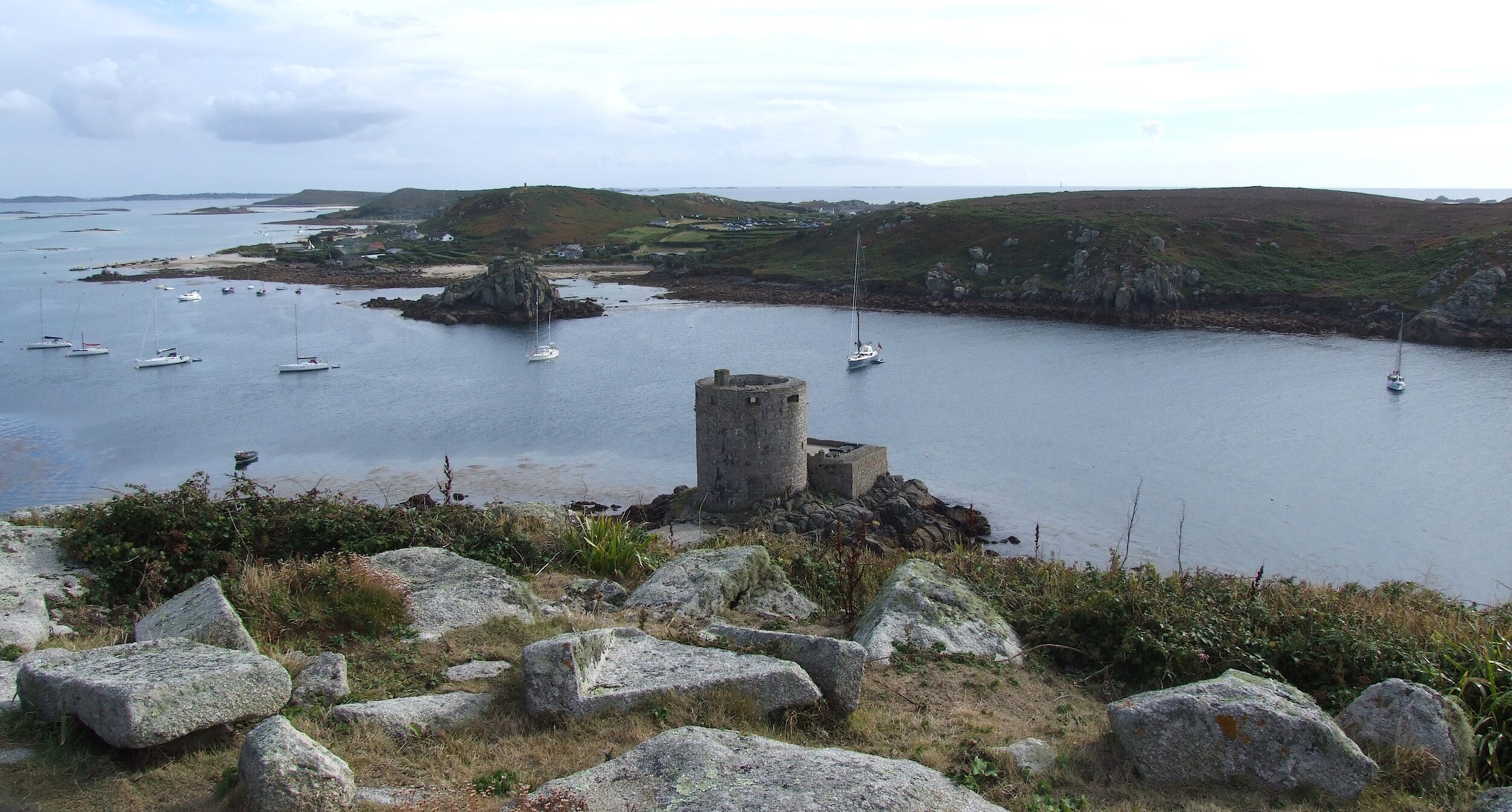
But the grim hill soon brings the walker a satisfying reward as the next stretch offers some of the most pleasant hiking in Scilly. As you head back down south toward The Town (which, by-the-way, is the most exaggerated place-name I've ever come across describing, as it does, half-a-dozen dwellings) the path runs high along the side of the Tresco Channel which is a sort of fjord between the two islands.

Just a few hundred yards across this dramatic sound Cromwell's Castle sits solid and cylindrical on Tresco's rocky shore. The castle was built in 1651 when there was a fear that the Dutch might invade, but in these somewhat happier times yachts from The Lowlands and many other countries now overnight peacefully under the ramparts.

Track that passes for the main road on Bryher
As we reach the southern edge of Shipmanhead Down, so the great vista of the central Scillonian archipelago opens up and this splendid apparition alone is enough to earn Bryher a bag full of brownie points in the inter-island popularity game.
View from Tresco across Cromwell’s Castle to Bryher


